UP TO THE MINUTE






Post-Hurricane Michael Aerial Imagery to Aid in Cleanup and Recovery Efforts
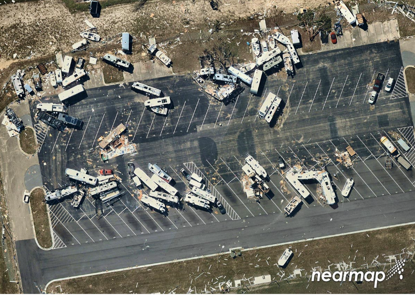
Aerial maps help public safety organizations, utility companies and insurance agencies clearly see damaged areas and compare to historical photos.
Nearmap, a premium global location content provider specializing in high-resolution, aerial maps, is capturing areas of the Florida Panhandle in the path of Hurricane Michael. Current, high-resolution aerial imagery aids cleanup and recovery efforts in many industries, including public safety, utility companies, insurance agencies and numerous types of contractors. The images are expected to be available in the next few days.
Nearmap plans to capture imagery of affected areas from Panama City to Apalachicola. The Panama City area was flown as recently as December 2017 with additional captures dating back to July 2016. Previous aerial maps allow Nearmap users to compare current imagery with historical photos.
Nearmap customers use aerial imagery to assist in the following aspects of post-disaster cleanup
- Public Safety: Access to immediate, crystal-clear aerial imagery of areas affected by storm damage for emergency response routing and safety.
- Utilities: View all areas where above-ground utilities have been affected and also see where infrastructure is down or damaged and causing hazards.
- Reconstruction Efforts: Compare historical image captures with post-event imagery to see structure elements and provide proper measurements to rebuild.
- Insurance: View impacted properties to see first-hand damage and potential structural damage.
All pre- and post-hurricane imagery is accessed through a standard web browser using Nearmap’s intuitive MapBrowser™, through Nearmap partners, or via APIs to integrate with common GIS, CAD and other applications.
Nearmap imagery is published at sub-7 cm Ground Sampling Distance (GSD), which allows users to see great detail on the ground. At this resolution, they can clearly identify important ground conditions such as roof blow-off, property damage and flooding. The same is true for streets and all other ground features, providing details for users to complete analysis both pre and post storms.
In addition to high-resolution, top-down images, Nearmap plans to process oblique imagery of the Panama City and Lynn Haven areas to further aid in assessing damage and providing recovery to these affected areas.
For more information, visit http://go.nearmap.com/hurricane-michael.
About Nearmap - Nearmap brings the real world to you. Nearmap delivers high-resolution aerial imagery as a service to businesses across the world, powered by industry-leading geospatial mapping technology. Using its own patented camera systems and processing software, Nearmap captures wide-scale urban areas in the U.S., Australia and New Zealand multiple times each year, making fresh content instantly available in the cloud via web app or API integration.
Every day, Nearmap helps thousands of users conduct virtual site visits for deep, data-driven insights—enabling informed decisions, streamlined operations and robust bottom lines.
Founded in Australia in 2007, Nearmap is one of the ten largest aerial survey companies in the world by annual data collection volume and is publicly listed in the ASX 300.
View a current project in Nearmap today. For more information, visit http://go.nearmap.com.
Recommended For You

Redefining jobsite cleanup with roofer-built solutions
Read More ...
Making TapcoSlate® easy to install
Read More ...
Reimagined roof repair packaging
Read More ...
UP TO THE MINUTE
Comments
Leave a Reply
Have an account? Login to leave a comment!
Sign In