
Polycam brings pro-grade 3D scanning to 800 million iPhone users for free, no LiDAR required
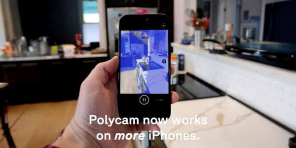
Polycam, the leading mobile 3D capture platform, announced the availability of 3D spatial capture on non-LiDAR iPhones, making it possible for anyone with an iPhone 13 or newer to create 3D scans using only a standard camera.
Historically, capturing spaces with Polycam was restricted to users with more expensive iPhone Pro and iPad Pro devices equipped with LiDAR sensors. This update removes that barrier. According to Consumer Intelligence Research Partners, more than half of iPhones sold are non-Pro models. This update effectively opens professional-grade 3D scanning to an estimated 800 million people for free.
"Spatial capture is increasingly essential for the millions of people who work with physical space. You used to need thousands of dollars of specialized equipment. Starting today, all you need is a regular iPhone," said Elliott Spelman, co-founder and CEO of Polycam.
Why this matters: Access at global scale
Modern work depends on understanding physical space. From homes, job sites, historical landmarks and classrooms, the ability to capture the real world in 3D has enormous implications for how people plan, document and change our spaces.
For decades, this capability has been reserved for a narrow group of professionals with specialized tools. By enabling spatial capture on non-LiDAR devices, Polycam dramatically expands access to 3D scanning, opening the door to hundreds of millions of additional iPhone users globally.
The innovation: Speed, quality and portability
Instead of relying on dedicated laser sensors, Polycam's new approach uses computer vision and machine learning to infer spatial depth from video captured on a standard camera. Scanning a space is as simple as recording a video. During capture, an on-device AI model provides real-time visual feedback to help users scan efficiently: no internet connection required. After capture, users choose: process immediately on-device for fast, accurate results anywhere or upload to the cloud for maximum detail.
Eliminating the barriers to 3D capture
Previously, capturing accurate 3D models of spaces required expensive hardware or significant technical expertise:
- No expensive hardware: Traditional laser scanners cost anywhere from $10,000 to $100,000+. With Polycam, anyone with an iPhone 13 or newer can scan in 3D for free, no LiDAR required.
- No technical expertise required: Photogrammetry, the traditional method of creating 3D models from photos, requires 50–200+ photos and lengthy cloud processing. With Polycam, capture a space in a single walkthrough, with processing in minutes.
- No time-consuming setup: Traditional scanning requires calibration, tripod placement and post-processing that can stretch a room scan into an hour. With Polycam, capture a room in minutes.
- Dimensionally accurate output: Polycam achieves the tolerances required for interior visualization and room layouts.
Polycam by the numbers
- Over 34 million captures created with Polycam since launch.
- Over 2 billion square feet of real-world spaces captured.
- Individuals in more than half of the Fortune 500 actively use Polycam.
- The only 3D scanning platform that works across iOS, Android and web.
Availability
Polycam is now available with iPhone 13 and newer, iPad mini (6th generation), iPad (10th generation) and iPad Air (5th generation) and later. All users can capture 3D scans, use measurement tools, comment and share links at no cost. Professional 3D exports and virtual walkthrough require paid plans. Floorplan generation and Android support without LiDAR are coming in 2026.
Recommended For You

ServiceTitan announcing new and expanded capabilities at Pantheon 2026
Read More ...
Chem Link Launches Two New NOVALINK Products
Read More ...
3 Reasons to Give Metal the Old College Try
Read More ...
UP TO THE MINUTE






Comments
Leave a Reply
Have an account? Login to leave a comment!
Sign In